
A Look at the Vibrant & Diverse Geography of Israel

The Sea of Galilee in northern Israel
Did you know that Israel is the only nation on earth that entered the 21st century with a net gain of trees within its borders? How about that! Al Gore should be proud, but what’s inconvenient about this truth is that Israel is largely a desert. So, how on earth did one of the smallest countries in the world, half of it sun-baked desert, manage this feat? Well, I personally think that God’s promise in Isaiah 35 might have something to do with it-
“In those days… the deserts will become as green as the mountains of Lebanon, as lovely as Mount Carmel or the plain of Sharon. There the Lord will display his glory, the splendor of our God.” -Isa. 35:1a & 2b
Any way you look at it, Israel is flourishing. Personally, I find it so exciting to see correlation between ancient Scripture and today’s Israel. I also thought this little fact was a fitting introduction to Israel’s geography.
That is, of course, the aim of this post. We’re working on a new series to educate American Christians on modern Israel and her historical background. As we tackle the history and character of Israel and her people, we are hoping to bring this distant country a lot closer to home- and a lot closer to our hearts in the Christian Church.
Israel’s Size
Israel is vibrant, diverse, and fully alive. And its geography mirrors this. About the only small thing about Israel is its physical size. Israel is composed of 7,992 square miles of land mass and 172 square miles of inland water- or a touch over 11,000 square miles if one includes the ambiguous and contentious Palestinian territories into the landmass equation. But that’s a discussion best saved for another post.
To put those numbers into perspective, Israel is about the same size as New Jersey. It’s approximately 260 miles from top to bottom, and at its widest point, a mere 70 miles wide. I know people who routinely ride their bikes farther than that. It’s a short 35 mile jaunt from the Mediterranean Sea on Israel’s east side to Jerusalem on Israel’s western slope, and even I’ve ridden a bike that far. So, yes, Israel is small.
Israel’s Regional Location, Neighbors and Major Cities
Israel sits on the eastern edge of the Mediterranean, and is technically part of the Asian continent, but it is more commonly associated with the region known as the Middle East. Israel is bordered by Lebanon to the north, Syria to the northeast, Jordan to the east and southeast, and Egypt to the southwest. Israel has approximately 112 miles of coast line, most of which is on the Mediterranean. However Israel’s southern tip has a small portion of coastline on the Gulf of Aqaba in the Red Sea.
Israel’s capital is Jerusalem in the central western portion of the country. Other major population centers are Tel Aviv/Jaffa located on the central Mediterranean coast and Haifa, a further 50 miles north along the cost. Most of Israel’s near 8 million citizens reside in the more temperate northern half of the country.
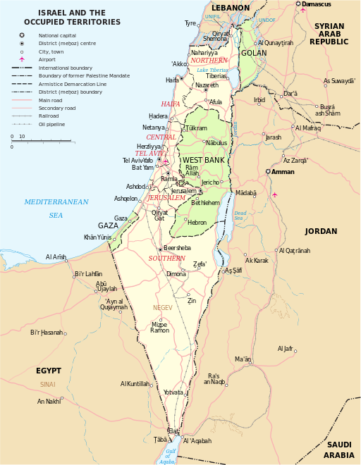
It’s worth mentioning at this point, that there are two Israeli administered territories, popularly referred to as the West Bank and Golan (light green in the above map). The status of both is not fully internationally defined. As such, they are a significant source of debate between Israelis and Palestinian Arabs. The land area of these territories was captured by Israel from Jordan and Syria during the wars of 1948 and 1967 and remain under full or partial Israeli administration. For most purposes, these territories are commonly considered part of Israel. The land is no longer claimed by either Syria or Jordan. However, the borders were never internationally recognized as constituting part of modern Israel, and as such, they are more like America’s frontier in the 18th and 19th century.
The West Bank is really a misnomer from past Jordanian control, and refers to the area of land on the west bank of the Jordan River directly east of Jerusalem. The area is more correctly referred to as Judea and Samaria, and is the same area referred to in the Bible. The West Bank is approximately 2100 square miles and looks like a backwards capital ‘B’ situated east of Jerusalem along the border of Israel and Jordan.
The Golan Heights sit atop the north end of Israel, along the border of Syria. This 1500 square mile area is under full Israeli administration and is less contested by Arab presence. A third, smaller, land area called Gaza was also an Israeli administered territory until a full Israeli withdraw in 2005. The area is now administered by Hamas, which is a Muslim Brotherhood based Palestinian organization. Gaza sits in the southwest corner of Israel along the Mediterranean cost and the border of Egypt.
Geographical Regions
Geographically, Israel is separated into four regions. They are the Coastal Plain, the Jordan Rift Valley, the Negev, and the Central Hills. Israel is separated east from west by a mountain range running north to south that helps define the climate and geography of these regions.
The Coastal Plain runs from Lebanon to Egypt along the coast. In the south, it generally reaches approximately 25 miles inland, and narrows to just 3 miles in the north. The region is near sea level and largely flat. Fertile and humid, it is responsible for a great deal of agriculture and is renowned for its citrus. Two of Israel’s major population centers lie within this region along the coast, including Tel Aviv and Haifa.

Israel’s coastal plain is fertile, humid, and stretches the length of the Mediterranean coast.
The Central Hills or plateau runs southward from the borders of Lebanon and Syria in Israel’s north along the center of the country until they give way to the Negev approximately 40 miles south of Jerusalem in Israel’s center. They are more temperate than the coastal region or the Negev to the south, and are dominated by hills, valleys, and small mountains. They average 2100 feet in elevation, with the highest point being the summit of Mt. Hermon at 3,963 feet in the Golan. Jerusalem sits atop this plateau, as do Judea and Samaria. Much of Israel’s prophetic and thriving grape and wine industries lie in this region.

Easily confused with California’s wine country, Israel’s central hills are a beautiful mix of green hills, deciduous and coniferous forests, and productive grape orchards.
If the Coastal Plain defines the western border of the Central Hills region, the Jordan Rift Valley defines its eastern boundary. Part of the Syrian-East African fault, the Jordan Rift Valley comprises Israel’s eastern watershed, and is dominated by the Sea of Galilee in the north, the Dead Sea to the south, and the Jordan River flowing south to connect the two. The Sea of Galilee, also known as Lake Kinneret or Lake Tiberias, is freshwater and the primary source of water for much of Israel. The Dead Sea is so named because its extremely salty water will not support any life form, and it does not have an outlet. It is also the lowest point on earth at 1,378 feet below sea level. The Jordan River connects the two bodies of water and dominates much of the valley’s geography. The Jordan also serves as the international boundary between Israel and Jordan.

The Jordan Rift Valley is a fertile slice of agriculture and riparian wilderness, much of it below sea level.
The Negev is Israel’s largest geographic region, and dominates the southern half of the country. This arid desert is geographically an extension of Egypt’s Sinai, and topographically mirrors Israel’s north, with plains to the west, hills in the center, and a wide valley on the east. Receiving an average of seven inches of rain annually, soils range from reasonably fertile in the north, to sandy in the central highland, and infertile and impervious in the south. The Negev is more sparsely populated than the rest of Israel, with Beersheba on its northern edge and the resort city of Eilat on the Red Sea at its southern most point.

The Negev, an extension of the Sinai Desert, makes up Israel’s arid southern half.
Israel is dominated by a Mediterranean climate, with dry, hot summers and cool, rainy winters. Annual rainfall is mostly recorded between November and March and is unevenly distributed to Israel’s northern regions. Average temperatures fluctuate between 50 degrees Fahrenheit in the winter to 80 in the summer as a national average. Temperatures in the Negev are much higher, with summer highs around 112. Tel Aviv averages high 90’s in the summer and mid 70’s in the winter, with high humidity. Jerusalem is cooler and less humid, with summer temperatures in the mid 80’s and winter temperatures in the mid 50’s. The Central Hills region receives most of the precipitation and sees snow in varying amounts each year.
Israel’s Ecology
Israel has an extremely diverse ecology. With the coast, mountains, desert, and rivers, Israel has a broad range of plant and animal life. Southwestern American desert dwellers will love this fact- a local native born Israeli is called a Sabra, which is the Hebrew word for Prickly Pear Cactus- which they also have in Israel. Yet Californians would feel at home in the green hills of Judea and Samaria dotted with trees and shrubs and grape orchards. Of course these diverse habitats support equally diverse animal life, from deer and squirrels to exotic animals like the Arabian Leopard, Striped Hyena and Camel. Though locally extinct now, recent animal inhabitants of Israel included Syrian brown bear, Nile crocodile, and Cheetah. Over 500 species of bird migrate through Israel, and there are a broad range of insects, amphibians, and reptiles.
Bible record talks about God leading the Hebrew people to a fertile and prosperous land 3,500 years ago. Yet, Bible record also makes it clear that this land would become desolate and inhospitable after Israel went into captivity in Babylon. But God is faithful to restore. God promised that He would once again restore this land, and He would bring the people of Israel back to their homeland. The last 100 years have seen this come to light. A recently inhospitable land that was largely unpopulated has been miraculously transformed into a prosperous and profitable land. The people of Israel are back and returning in record numbers. A land Mark Twain described in an 1867 visit as wholly desolate of trees and people is now a thriving agricultural powerhouse, providing 95% of its own food.
The land of Israel is alive. There is really no other way to put it. This remarkable revival of dry bones is such a powerful testimony of God’s redeeming power. God can and will make things live again. Israel is the national proof. To see this with my own eyes has added such depth to my faith I cannot do it justice here. If God is faithful to fulfill prophecy, how much more so will He faithfully stand by His promises to you.
Join us next week for a look at the thriving culture and demography of modern Israel! In the meantime, connect with us on Facebook, Twitter and Pinterest!

Pingback: Discovering Israel Part 2- demographics, government and economy |·
Pingback: Is War Brewing in the Middle East? |·